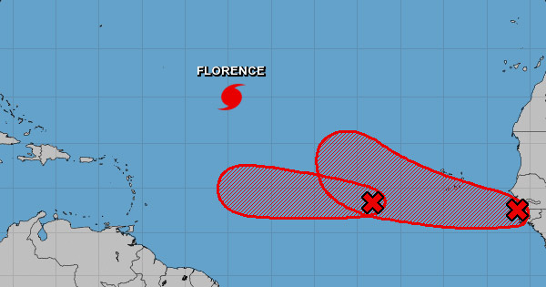
Invest 92-L, a broad and elongated area of low pressure located several hundred miles to the south-southwest of the Cape Verde Islands, still looks to become our next named tropical storm — Helene — over the next several days or so. It is expected that Invest 92-L will be steered along a westerly to west-northwesterly track over the next several days as a ridge of high pressure will be positioned to its north.
Looking to next week the question becomes how big of a threat does this system pose to the Lesser Antilles and the Caribbean region in general. Overall, the forecast models are not providing much insight. One model has been inconsistent, wavering from a definite threat to the eastern Caribbean, to the system either dissipating altogether, to a track that takes this system well north and east of the Caribbean. Another model forecasts the system to curve to the north and stay well east of the Lesser Antilles.
Invest 92-L, is at this point, a system to keep an eye on as we are more than a week out from it even threatening the Lesser Antilles. It is quite possible that Invest 92-L may be pulled northward into the open Atlantic by an upper level trough of low pressure left behind by Hurricane Florence. It is also just as possible that the upper level trough may not be strong enough, resulting in Invest 92-L being guided westward towards the Caribbean during next week.
Elsewhere, a tropical wave is forecast to move off the west coast of Africa on Friday. Development of this system is anticipated after that time, and a tropical depression could form over the weekend or early next week while the wave moves westward or west-northwestward over the far eastern tropical Atlantic Ocean. There is a 60 percent chance of development over the next five days.
